GEO Satellites: Understanding the Technology and Applications
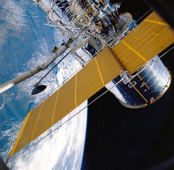
GEO satellites, or Geostationary Earth Orbit satellites, are a type of satellite that orbits the Earth at an altitude of approximately 36,000 kilometers. They are stationed above the equator and remain fixed in relation to a specific point on the Earth’s surface, allowing them to provide continuous coverage of a particular region. GEO satellites have been instrumental in shaping the modern telecommunications landscape, enabling global connectivity and facilitating a wide range of applications.
The first GEO satellite, Syncom 2, was launched in 1963, and since then, hundreds of GEO satellites have been launched into orbit. These satellites have played a critical role in providing telecommunications services, including television broadcasting, telephone connectivity, and internet access. They have also been used for weather forecasting, navigation, and remote sensing applications.
How GEO Satellites Work
GEO satellites work by receiving signals from Earth stations and re-transmitting them back to Earth. They are equipped with transponders, which are devices that receive and re-transmit signals. The transponders on a GEO satellite are typically connected to a series of antennas, which are used to receive and transmit signals. The satellite’s position in geostationary orbit allows it to maintain a fixed position relative to a specific point on the Earth’s surface, enabling it to provide continuous coverage of a particular region.
The signals transmitted by a GEO satellite are typically in the form of radio waves, which are received by Earth stations and decoded into the original signal. The signal is then re-transmitted back to the satellite, which amplifies and re-transmits it back to Earth. This process allows GEO satellites to provide global coverage and enable a wide range of applications.
Applications of GEO Satellites
GEO satellites have a wide range of applications, including telecommunications, weather forecasting, navigation, and remote sensing. They are used to provide television broadcasting, telephone connectivity, and internet access to remote and underserved areas. They are also used for navigation and tracking applications, such as GPS and other satellite-based navigation systems.
In addition to these applications, GEO satellites are also used for remote sensing and Earth observation applications. They are equipped with sensors and cameras that can capture high-resolution images of the Earth’s surface, allowing scientists to monitor climate change, track natural disasters, and study the Earth’s ecosystems.
Benefits and Challenges of GEO Satellites
The use of GEO satellites has several benefits, including global coverage, high bandwidth, and reliability. They are also relatively low-cost compared to other types of satellites, making them an attractive option for many applications. However, GEO satellites also have some challenges, including congestion in the geostationary orbit, interference from other satellites, and the risk of collisions with other objects in orbit.
Despite these challenges, GEO satellites continue to play a critical role in modern telecommunications and will likely remain an essential part of the global telecommunications infrastructure for the foreseeable future.


