GEO Satellites: Understanding the Technology and Applications of Geostationary Orbit Satellites

GEO satellites, or geostationary orbit satellites, are a type of satellite that orbits the Earth at an altitude of approximately 36,000 kilometers above the equator. The Focus Keyword: GEO satellites have a unique characteristic that allows them to maintain a fixed position relative to a point on the Earth’s surface, making them ideal for a wide range of applications. In this article, we will delve into the technology and applications of GEO satellites, exploring their history, design, and uses.
The concept of GEO satellites was first proposed by science fiction writer Arthur C. Clarke in 1945. Clarke suggested that a satellite in geostationary orbit could be used to transmit signals to a wide area of the Earth’s surface, providing a reliable and efficient means of communication. The first GEO satellite, Syncom 2, was launched in 1963 by NASA, and it paved the way for the development of modern telecommunications systems. Today, GEO satellites are used for a variety of purposes, including telecommunications, navigation, weather forecasting, and Earth observation.
One of the primary advantages of GEO satellites is their ability to provide continuous coverage of a specific region. Because they maintain a fixed position relative to the Earth’s surface, GEO satellites can transmit signals to a wide area without interruption. This makes them ideal for applications such as telecommunications, where a reliable and consistent signal is essential. Additionally, GEO satellites can be used to provide internet connectivity to remote or underserved areas, helping to bridge the digital divide and promote economic development.
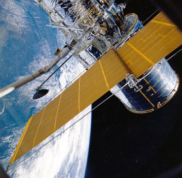
In terms of design, GEO satellites are typically equipped with a range of instruments and antennas that allow them to transmit and receive signals. They are also equipped with solar panels and batteries, which provide power to the satellite’s systems. The most common type of GEO satellite is the communications satellite, which is used to transmit signals for telecommunications, television broadcasting, and other applications. Other types of GEO satellites include navigation satellites, which provide location information and timing signals, and weather satellites, which monitor the Earth’s atmosphere and oceans.
The applications of GEO satellites are diverse and far-reaching. In addition to telecommunications and navigation, they are used for weather forecasting, Earth observation, and scientific research. For example, the GOES (Geostationary Operational Environmental Satellite) series of satellites, operated by NASA and the National Oceanic and Atmospheric Administration (NOAA), provides critical weather forecasting data and imagery to meteorologists and researchers. Similarly, the Landsat series of satellites, operated by NASA and the United States Geological Survey (USGS), provides high-resolution images of the Earth’s surface, which are used for land use planning, disaster response, and environmental monitoring.
Despite the many advantages of GEO satellites, there are also challenges and limitations associated with their use. One of the primary concerns is the risk of satellite congestion, which occurs when too many satellites are operating in the same orbit. This can lead to interference and signal degradation, reducing the effectiveness of the satellites. Additionally, GEO satellites are vulnerable to space debris and other hazards, such as solar flares and cosmic radiation, which can damage their instruments and systems.
In conclusion, GEO satellites play a vital role in modern telecommunications, navigation, and weather forecasting. Their unique characteristic of maintaining a fixed position relative to the Earth’s surface makes them ideal for a wide range of applications. As technology continues to evolve, it is likely that GEO satellites will remain an essential part of our global infrastructure, providing critical services and supporting economic development and scientific research.


