GEO Satellites: Understanding the Technology and Applications
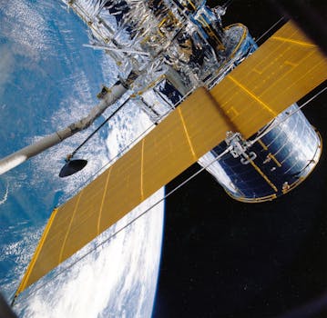
GEO satellites, or Geostationary Earth Orbit satellites, are a type of satellite that orbits the Earth at an altitude of approximately 36,000 kilometers. At this altitude, the satellite’s orbital period is synchronized with the Earth’s rotational period, allowing it to remain stationary in the sky relative to a fixed point on the Earth’s surface. This unique characteristic makes GEO satellites ideal for a wide range of applications, including telecommunications, weather forecasting, and Earth observation.
GEO satellites have been in use for several decades, with the first GEO satellite, Syncom 2, launched in 1963. Since then, the technology has evolved significantly, with modern GEO satellites offering higher capacity, greater flexibility, and improved performance. Today, GEO satellites play a vital role in modern telecommunications, providing global coverage and enabling a wide range of applications, including broadband internet, mobile communications, and television broadcasting.
How GEO Satellites Work
GEO satellites work by transmitting and receiving signals to and from Earth stations, which are located on the ground. The satellite receives signals from the Earth station, amplifies them, and then re-transmits them back to Earth, where they are received by other Earth stations. This process allows GEO satellites to provide global coverage, enabling communications between different parts of the world.
GEO satellites use a range of frequencies to transmit and receive signals, including C-band, Ku-band, and Ka-band. Each frequency band has its own advantages and disadvantages, with C-band offering wider coverage but lower capacity, and Ka-band offering higher capacity but narrower coverage. The choice of frequency band depends on the specific application and the requirements of the user.
Applications of GEO Satellites
GEO satellites have a wide range of applications, including telecommunications, weather forecasting, and Earth observation. In telecommunications, GEO satellites are used to provide broadband internet, mobile communications, and television broadcasting. They are also used to provide connectivity to remote and underserved areas, where terrestrial infrastructure is limited or non-existent.
In weather forecasting, GEO satellites are used to monitor the Earth’s atmosphere and oceans, providing valuable data on weather patterns and climate trends. They are also used to track hurricanes, typhoons, and other severe weather events, enabling early warnings and emergency response.
In Earth observation, GEO satellites are used to monitor the Earth’s surface, providing data on land use, deforestation, and environmental changes. They are also used to track natural disasters, such as earthquakes, tsunamis, and wildfires, enabling rapid response and recovery.
Challenges and Limitations of GEO Satellites
Despite their many advantages, GEO satellites also have some challenges and limitations. One of the main challenges is the high cost of launching and operating a GEO satellite, which can be prohibitively expensive for many organizations. Additionally, GEO satellites are vulnerable to interference from other satellites and terrestrial systems, which can impact their performance and availability.
Another limitation of GEO satellites is their relatively low capacity compared to other types of satellites, such as Medium Earth Orbit (MEO) and Low Earth Orbit (LEO) satellites. This can make them less suitable for applications that require high-speed data transfer, such as online gaming and video streaming.
Finally, GEO satellites are also subject to regulatory restrictions and international agreements, which can limit their use and deployment. For example, the International Telecommunication Union (ITU) regulates the use of satellite frequencies and orbits, and countries must comply with these regulations to avoid interference and ensure safe operations.
Future of GEO Satellites
Despite the challenges and limitations, the future of GEO satellites looks bright. Advances in technology are enabling the development of more powerful and efficient GEO satellites, with higher capacity and greater flexibility. Additionally, new applications and services are emerging, such as satellite-based 5G networks and IoT connectivity.
Furthermore, the growing demand for satellite-based services, particularly in emerging markets, is driving investment and innovation in the GEO satellite sector. New launch vehicles and satellite manufacturers are entering the market, offering more competitive pricing and greater choice for customers.
In conclusion, GEO satellites play a vital role in modern telecommunications, providing global coverage and enabling a wide range of applications. While they have some challenges and limitations, advances in technology and growing demand are driving innovation and investment in the sector. As the world becomes increasingly connected, the importance of GEO satellites will only continue to grow.


