Exploring GEO Satellites: Unlocking the Potential of Geostationary Orbit
GEO Satellites: Unlocking the Potential of Geostationary Orbit
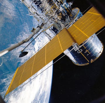
GEO satellites, short for Geostationary Orbit satellites, are a crucial component of modern telecommunications and navigation systems. Geostationary orbit, also known as geosynchronous equatorial orbit, is a circular orbit around the Earth at an altitude of approximately 36,000 kilometers. At this altitude, a satellite’s orbital period matches the Earth’s rotational period, allowing it to remain stationary relative to a fixed point on the Earth’s surface. This unique characteristic makes GEO satellites ideal for a wide range of applications, including telecommunications, weather forecasting, and navigation.
GEO satellites have been in use for several decades, with the first geostationary satellite, Syncom 2, launched in 1963. Since then, the technology has evolved significantly, with modern GEO satellites boasting advanced capabilities such as high-gain antennas, transponders, and propulsion systems. These advancements have enabled GEO satellites to provide a wide range of services, including television broadcasting, internet connectivity, and mobile communications.
Applications of GEO Satellites
GEO satellites have a wide range of applications, including telecommunications, weather forecasting, navigation, and Earth observation. In the field of telecommunications, GEO satellites are used to provide internet connectivity, mobile communications, and television broadcasting. They are also used for weather forecasting, providing images of cloud patterns, sea surface temperatures, and other meteorological data. Additionally, GEO satellites are used for navigation, providing location information and timing signals for GPS and other navigation systems.
In addition to these applications, GEO satellites are also used for Earth observation, providing data on climate change, ocean currents, and land use patterns. They are also used for disaster response and recovery, providing critical communications and navigation services during emergencies. Furthermore, GEO satellites are used for scientific research, providing data on the Earth’s magnetosphere, radiation belts, and upper atmosphere.
Benefits of GEO Satellites
GEO satellites offer several benefits, including global coverage, high-gain antennas, and long-term operations. With a single GEO satellite, it is possible to cover a significant portion of the Earth’s surface, providing services to a large number of users. Additionally, GEO satellites are equipped with high-gain antennas, which enable them to transmit and receive signals with high power and precision. This allows for high-quality communications and navigation services, even in areas with limited infrastructure.
GEO satellites also have long-term operations, with some satellites remaining in orbit for up to 15 years or more. This provides a high degree of stability and reliability, enabling operators to plan and invest in long-term services and applications. Furthermore, GEO satellites are relatively low maintenance, with most operations being automated and remotely controlled. This reduces the need for manual intervention and minimizes the risk of human error.
Challenges and Limitations of GEO Satellites
Despite the many benefits of GEO satellites, there are also several challenges and limitations to their use. One of the main challenges is the high cost of launch and operation, which can be a significant barrier to entry for new operators. Additionally, GEO satellites are subject to orbital congestion, with a limited number of available slots in geostationary orbit. This can lead to conflicts between operators and limit the availability of services.
Another challenge facing GEO satellites is the risk of interference and jamming, which can disrupt communications and navigation services. This can be caused by a variety of factors, including solar activity, meteor showers, and human error. Furthermore, GEO satellites are also subject to the effects of space weather, including radiation and extreme temperatures, which can affect their performance and lifespan.
Future of GEO Satellites
Despite the challenges and limitations facing GEO satellites, the future of this technology looks bright. With advances in satellite technology and the development of new applications, GEO satellites are likely to continue playing a critical role in modern telecommunications and navigation systems. One of the most significant trends in the GEO satellite industry is the development of high-throughput satellites, which offer faster data rates and higher capacities.
Another trend is the increasing use of electric propulsion systems, which provide higher efficiency and longer-term operations. This is expected to lead to a new generation of GEO satellites with improved performance and capabilities. Furthermore, the development of small satellites and satellite constellations is also expected to have a significant impact on the GEO satellite industry, providing new opportunities for operators and users alike.


