GEO Satellites: Understanding the Technology and Applications of Geostationary Earth Orbit Satellites
GEO Satellites: Understanding the Technology and Applications of Geostationary Earth Orbit Satellites
GEO satellites, or geostationary earth orbit satellites, are a type of satellite that orbits the Earth at an altitude of approximately 36,000 kilometers above the equator. At this altitude, the satellite’s orbital period matches the Earth’s rotational period, allowing it to remain stationary relative to a fixed point on the Earth’s surface. This unique characteristic makes GEO satellites an essential component of modern telecommunications, navigation, and weather forecasting systems.
GEO satellites have been in use for several decades, with the first GEO satellite, Syncom 2, launched in 1963. Since then, the technology has rapidly evolved, with significant advancements in satellite design, propulsion systems, and payload capacity. Today, GEO satellites play a vital role in providing global communications, navigation, and weather forecasting services.
Technological Overview of GEO Satellites
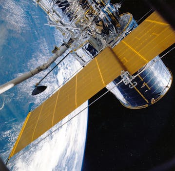
A typical GEO satellite consists of a bus, which provides the structural and mechanical support for the satellite, and a payload, which includes the communication equipment, antennas, and other instruments. The bus is equipped with solar panels, which provide power to the satellite, and a propulsion system, which maintains the satellite’s orbit and attitude. The payload, on the other hand, is designed to perform specific functions, such as transmitting and receiving signals, collecting data, or providing navigation services.
GEO satellites use a variety of frequencies to transmit and receive signals, including C-band, Ku-band, and Ka-band. The choice of frequency depends on the application, with C-band used for television broadcasting, Ku-band used for telecommunications and navigation, and Ka-band used for high-speed internet and data transmission. The satellites also use various modulation techniques, such as amplitude shift keying (ASK) and quadrature amplitude modulation (QAM), to encode and decode signals.
Applications of GEO Satellites
GEO satellites have a wide range of applications, including telecommunications, navigation, weather forecasting, and Earth observation. In telecommunications, GEO satellites provide global coverage, allowing for international communications, television broadcasting, and internet connectivity. Navigation systems, such as GPS and GLONASS, rely on GEO satellites to provide location information and timing signals. Weather forecasting services use GEO satellites to collect data on atmospheric conditions, ocean currents, and land surface temperatures.
In addition to these applications, GEO satellites are also used for Earth observation, disaster monitoring, and climate change research. They provide high-resolution images of the Earth’s surface, allowing scientists to study the environment, track natural disasters, and monitor climate patterns. The satellites also support search and rescue operations, providing critical information to emergency responders and disaster relief teams.
Future Developments and Challenges
The GEO satellite industry is expected to continue growing, with new technologies and innovations emerging in the coming years. One of the key trends is the development of high-throughput satellites (HTS), which offer faster data transmission rates and greater capacity. HTS satellites use advanced technologies, such as spot beams and frequency reuse, to increase bandwidth and reduce costs.
However, the GEO satellite industry also faces significant challenges, including congestion in the geostationary orbit, interference from other satellites, and the risk of collisions and space debris. To address these challenges, satellite operators and regulatory agencies are working together to develop new standards and guidelines for satellite operations, including measures to prevent collisions and mitigate the effects of interference.
In conclusion, GEO satellites are a vital part of modern telecommunications, navigation, and weather forecasting systems. Their unique characteristics, including their geostationary orbit and high altitude, make them an essential component of global communications and observation networks. As the technology continues to evolve, we can expect to see new innovations and applications emerge, further expanding the role of GEO satellites in our daily lives.