GEO Satellites: Understanding the Technology and Applications of Geostationary Orbit Satellites
GEO satellites are a type of satellite that orbits the Earth at an altitude of approximately 36,000 kilometers, remaining stationary relative to a fixed point on the planet’s surface. This article delves into the technology and applications of GEO satellites, exploring their history, functionality, and impact on various industries.
GEO Satellites: Understanding the Technology and Applications of Geostationary Orbit Satellites
GEO satellites, or geostationary orbit satellites, are a type of satellite that orbits the Earth at an altitude of approximately 36,000 kilometers, remaining stationary relative to a fixed point on the planet’s surface. This unique characteristic allows GEO satellites to provide continuous coverage of a specific region, making them ideal for a wide range of applications, including telecommunications, weather forecasting, and navigation.
The concept of GEO satellites was first introduced by science fiction writer Arthur C. Clarke in 1945, and the first GEO satellite, Syncom 2, was launched in 1963. Since then, hundreds of GEO satellites have been launched, with many more planned for the future. GEO satellites have revolutionized the way we communicate, navigate, and understand our planet, and have played a crucial role in shaping the modern world.
How GEO Satellites Work
GEO satellites work by orbiting the Earth at a speed that matches the planet’s rotation, allowing them to remain stationary relative to a fixed point on the surface. This is achieved by placing the satellite in a geostationary orbit, which is approximately 36,000 kilometers above the equator. At this altitude, the satellite’s orbital period matches the Earth’s rotational period, allowing it to remain stationary.
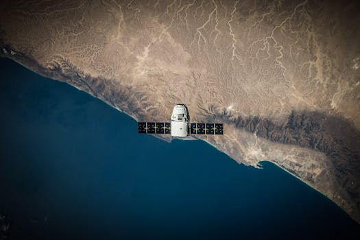
GEO satellites are typically equipped with a range of instruments, including transponders, antennas, and solar panels. The transponders receive and retransmit signals, allowing the satellite to communicate with Earth-based stations. The antennas are used to transmit and receive signals, while the solar panels provide power to the satellite’s systems.
Applications of GEO Satellites
GEO satellites have a wide range of applications, including telecommunications, weather forecasting, navigation, and Earth observation. In the telecommunications industry, GEO satellites are used to provide broadband internet, television broadcasting, and mobile phone services. They are particularly useful for providing coverage to remote or underserved areas, where traditional infrastructure may not be available.
In the field of weather forecasting, GEO satellites are used to monitor cloud patterns, track storms, and predict weather patterns. They are equipped with specialized instruments, such as radiometers and spectrometers, which allow them to collect data on atmospheric conditions, including temperature, humidity, and wind patterns.
GEO satellites are also used for navigation, providing location information and timing signals to GPS receivers on the ground. This allows for accurate positioning and navigation, which is critical for a range of applications, including aviation, maritime, and land transportation.
Challenges and Future Developments
Despite the many advantages of GEO satellites, there are also several challenges associated with their use. One of the main challenges is the risk of collision with other satellites or space debris, which can cause significant damage and disrupt services. Additionally, GEO satellites are susceptible to interference from other satellites or terrestrial sources, which can affect their performance and reliability.
To address these challenges, researchers and engineers are developing new technologies and strategies for managing GEO satellites. This includes the use of advanced propulsion systems, which allow satellites to maneuver and avoid collisions. There is also a growing focus on satellite servicing, which involves repairing or replacing faulty components in orbit, rather than launching new satellites.
In the future, we can expect to see significant advancements in GEO satellite technology, including the development of new instruments and sensors, and the use of artificial intelligence and machine learning to improve performance and efficiency. There will also be a growing focus on sustainability and environmental responsibility, as the satellite industry seeks to minimize its impact on the environment and reduce its carbon footprint.
Conclusion
In conclusion, GEO satellites are a critical component of modern telecommunications, navigation, and weather forecasting systems. Their unique characteristics, including their geostationary orbit and ability to provide continuous coverage, make them ideal for a wide range of applications. As the satellite industry continues to evolve and grow, we can expect to see significant advancements in GEO satellite technology, including the development of new instruments and sensors, and the use of artificial intelligence and machine learning to improve performance and efficiency.