The Role of Satellites in Global Weather Forecasting Systems
The role of satellites in global weather forecasting systems is a vital one, as they provide essential data and images that help predict weather patterns and storms. Satellites have revolutionized the field of meteorology, enabling forecasters to track weather systems and provide accurate warnings of severe weather events. In this article, we will explore the role of satellites in global weather forecasting systems and how they contribute to our understanding of the weather.
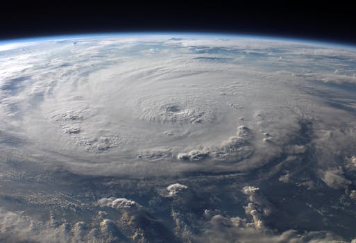
Satellites have been used in weather forecasting for several decades, with the first weather satellite, TIROS-1, launched by NASA in 1960. Since then, numerous satellites have been launched, each with improved capabilities and instrumentation. Today, there are several types of satellites used in weather forecasting, including geostationary satellites, polar-orbiting satellites, and radar satellites. Geostationary satellites, such as the Geostationary Operational Environmental Satellite (GOES), orbit the Earth at an altitude of approximately 36,000 kilometers and remain stationary over a fixed point on the equator. These satellites provide continuous imagery of the Earth’s weather patterns, allowing forecasters to track the movement of clouds, storms, and other weather systems.
How Satellites Contribute to Weather Forecasting
Satellites contribute to weather forecasting in several ways. Firstly, they provide visible and infrared imagery of the Earth’s surface and atmosphere, allowing forecasters to track the movement of clouds, storms, and other weather systems. This imagery is used to predict the formation and movement of high and low-pressure systems, fronts, and other weather phenomena. Secondly, satellites measure atmospheric conditions, such as temperature, humidity, and wind speed, which are essential for predicting weather patterns. Thirdly, satellites detect severe weather events, such as hurricanes, tornadoes, and blizzards, and provide critical data for warning systems.
Satellites also play a crucial role in monitoring climate change and its impact on the weather. By tracking changes in sea surface temperature, ice cover, and other climate indicators, satellites help scientists understand the effects of climate change on the weather. This information is used to improve climate models and predict future changes in the weather.
Types of Satellites Used in Weather Forecasting
There are several types of satellites used in weather forecasting, each with its own unique capabilities and instrumentation. Geostationary satellites, such as the GOES series, provide continuous imagery of the Earth’s weather patterns, while polar-orbiting satellites, such as the NOAA series, provide detailed atmospheric measurements. Radar satellites, such as the Tropical Rainfall Measuring Mission (TRMM), use radar to measure precipitation and other weather phenomena.
Additionally, satellites such as the European Space Agency’s (ESA) Meteosat Second Generation (MSG) series and the Japanese Himawari series provide high-resolution imagery and atmospheric measurements. These satellites are equipped with advanced instrumentation, such as hyperspectral imagers and atmospheric sounders, which provide detailed information about the Earth’s atmosphere and weather patterns.
Conclusion
In conclusion, the role of satellites in global weather forecasting systems is vital, providing essential data and images that help predict weather patterns and storms. Satellites have revolutionized the field of meteorology, enabling forecasters to track weather systems and provide accurate warnings of severe weather events. As technology continues to improve, satellites will play an increasingly important role in understanding and predicting the weather, ultimately saving lives and protecting property.


