The Role of Satellites in Global Weather Forecasting Systems
The role of satellites in global weather forecasting systems is a critical one, as they provide vital data and images that help predict weather patterns and storms. Satellites have been used for weather forecasting for decades, and their importance has only grown with advancements in technology. In this article, we will explore the role of satellites in global weather forecasting systems and how they contribute to our understanding of the weather.
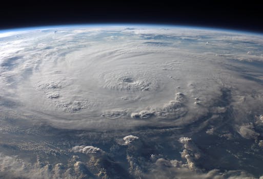
Satellites are able to collect data from all over the world, including remote and inaccessible areas, which makes them an essential tool for global weather forecasting. They can detect changes in the atmosphere, oceans, and land surfaces, which helps forecasters predict weather patterns and storms. Satellites also provide high-resolution images of the Earth, which can be used to track the movement of weather systems and monitor the development of storms.
How Satellites Contribute to Weather Forecasting
Satellites contribute to weather forecasting in several ways. They can detect changes in the atmosphere, such as temperature, humidity, and wind patterns, which helps forecasters predict weather patterns. Satellites can also detect changes in the oceans, such as sea surface temperature and ocean currents, which can impact weather patterns. Additionally, satellites can monitor the land surface, tracking changes in vegetation, soil moisture, and snow cover, which can also impact weather patterns.
Satellites use a variety of instruments to collect data, including radiometers, spectrometers, and radar. These instruments allow satellites to measure the temperature, humidity, and wind patterns in the atmosphere, as well as the temperature and moisture content of the land surface. Satellites can also use radar to detect precipitation and track the movement of storms.
Types of Satellites Used for Weather Forecasting
There are several types of satellites used for weather forecasting, including geostationary satellites, polar-orbiting satellites, and low-Earth orbit satellites. Geostationary satellites are located in a fixed position above the equator and provide continuous coverage of a specific region. Polar-orbiting satellites orbit the Earth at a high inclination, allowing them to cover the entire planet. Low-Earth orbit satellites orbit the Earth at a low altitude, providing high-resolution images of the Earth’s surface.
Examples of satellites used for weather forecasting include the Geostationary Operational Environmental Satellite (GOES) series, the Polar-orbiting Operational Environmental Satellite (POES) series, and the European Space Agency’s Meteosat series. These satellites provide vital data and images that are used by forecasters to predict weather patterns and storms.
Conclusion
In conclusion, satellites play a critical role in global weather forecasting systems, providing vital data and images that help predict weather patterns and storms. Their ability to collect data from all over the world, including remote and inaccessible areas, makes them an essential tool for global weather forecasting. With advancements in technology, the importance of satellites in weather forecasting will only continue to grow, allowing us to better understand and predict the weather.


