The Role of Satellites in Global Weather Forecasting Systems: Enhancing Prediction Accuracy
The Role of Satellites in Global Weather Forecasting Systems: Enhancing Prediction Accuracy
The role of satellites in global weather forecasting systems is vital, as they provide critical data for predicting weather patterns and storms. Satellites have revolutionized the field of meteorology, enabling scientists to monitor the atmosphere, oceans, and land surfaces from space. With the help of satellites, meteorologists can now predict weather patterns with greater accuracy, issue timely warnings for severe weather events, and improve our understanding of the Earth’s climate system.
Satellites in weather forecasting systems use various sensors to collect data on atmospheric conditions, such as temperature, humidity, wind speed, and direction. This data is then transmitted to ground stations, where it is processed and analyzed to create forecast models. The most commonly used satellite systems for weather forecasting are geostationary satellites, which remain stationary over a specific point on the Earth’s surface, and polar-orbiting satellites, which orbit the Earth at a lower altitude and provide more detailed data on atmospheric conditions.
Types of Satellites Used in Weather Forecasting
There are several types of satellites used in weather forecasting, each with its own unique capabilities and advantages. Geostationary satellites, such as the Geostationary Operational Environmental Satellite (GOES) system, provide continuous monitoring of the atmosphere and oceans, enabling scientists to track the movement of weather systems and predict severe weather events. Polar-orbiting satellites, such as the National Polar-orbiting Operational Environmental Satellite System (NPOESS), provide more detailed data on atmospheric conditions, including temperature, humidity, and wind speed.
Other types of satellites used in weather forecasting include low-Earth orbiting satellites, which provide high-resolution data on atmospheric conditions, and medium-Earth orbiting satellites, which provide data on the Earth’s radiation budget and the movement of weather systems. The European Organisation for the Exploitation of Meteorological Satellites (EUMETSAT) operates a fleet of satellites, including the Meteosat and Metop satellites, which provide critical data for weather forecasting and climate monitoring.
Applications of Satellites in Weather Forecasting
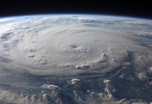
Satellites have a wide range of applications in weather forecasting, from predicting severe weather events to monitoring climate patterns. One of the most significant applications of satellites is in the prediction of severe weather events, such as hurricanes, typhoons, and tornadoes. Satellites can detect the formation of these storms and track their movement, enabling scientists to issue timely warnings and save lives.
Satellites are also used to monitor climate patterns, including the movement of high and low-pressure systems, the formation of fronts, and the movement of weather systems. This data is used to create forecast models, which are then used to predict weather patterns over the short-term and long-term. Satellites also play a critical role in monitoring the Earth’s radiation budget, which is essential for understanding the Earth’s climate system and predicting climate change.
Conclusion
In conclusion, the role of satellites in global weather forecasting systems is crucial, as they provide critical data for predicting weather patterns and storms. Satellites have revolutionized the field of meteorology, enabling scientists to monitor the atmosphere, oceans, and land surfaces from space. With the help of satellites, meteorologists can now predict weather patterns with greater accuracy, issue timely warnings for severe weather events, and improve our understanding of the Earth’s climate system. As satellite technology continues to evolve, we can expect even more accurate and reliable weather forecasts, which will have a significant impact on our daily lives and the economy.


